
The Apurímac River Canyon far below makes the high promontory even more dramatic. The ruins are at 4,140 meters above sea level (13,583 feet) and the river is at about 3,230 meters (10,600 ft). I think the location is much more impressive than Machu Picchu.
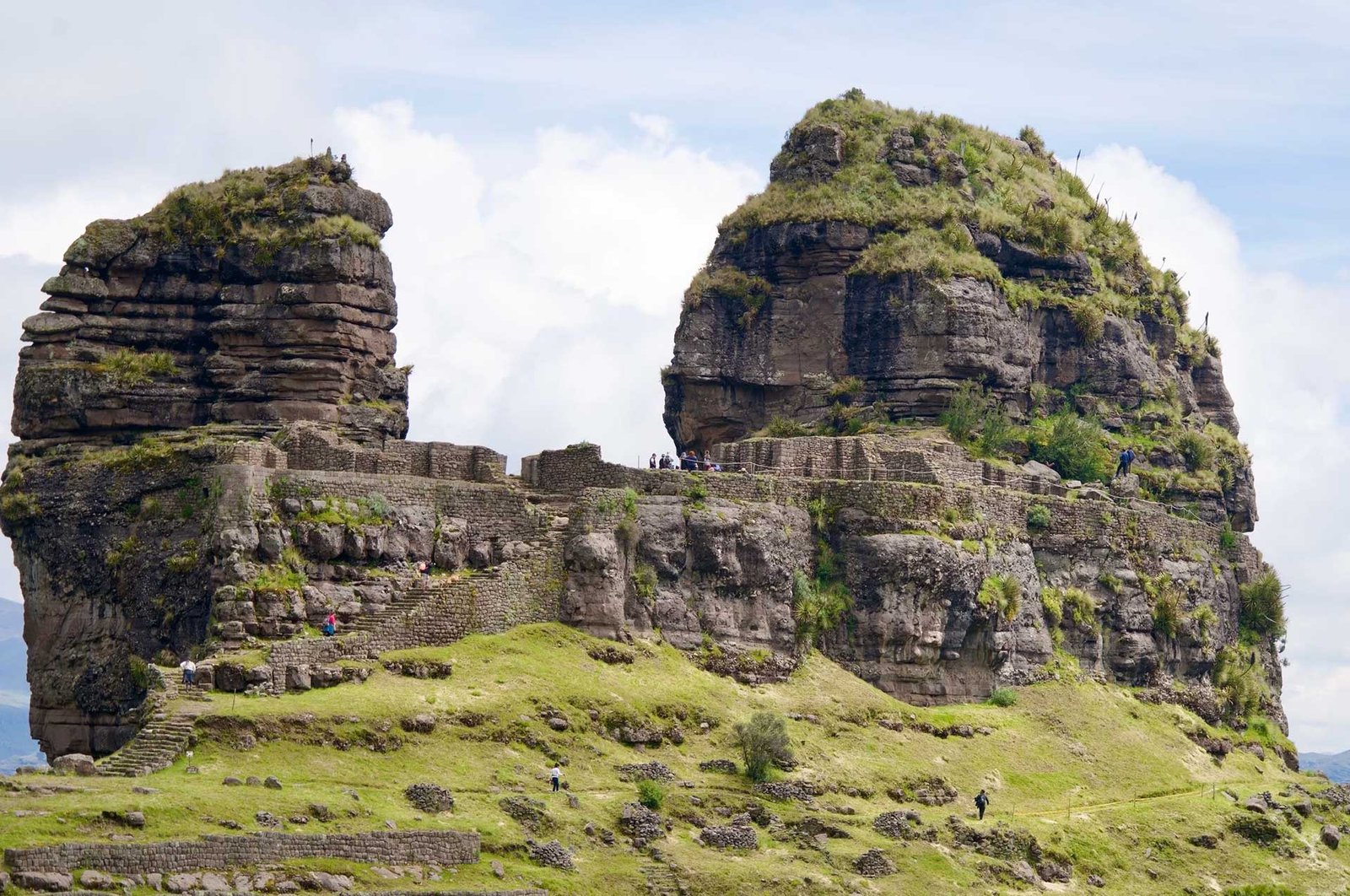
From a distance, Waqra Pukará seems completely natural. When you get closer, you’ll see the remnants of walls surrounding the site, flat areas that were obviously leveled by people and stairs leading up through one section of the wall. The site is naturally defensible, which is certainly why it was called a fortress. There is only one entrance to the ruins, unless you are a skilled rock climber or Spiderman.
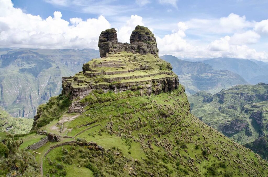
Waqra Pukará is one of the most spectacular Inca ruins in Peru and one of my top recommendations for alternatives to Machu Picchu. It’s an isolated tower, with two giant stone “horns” that give the site its name. Waqra is the Quechua word for horned and Pukará means fortress.
According to Inca lore, it was used as a fortress during a love affair which turned into an elopement and battle reminiscent of the fight over Helen of Troy. The residents of Sangarará tell of a common soldier who fell in love with the daughter of one of the Inca’s generals. They eloped to Sangarará and then fled to Waqra Pukará when the general discovered their hiding place.
There ensued a battle, which the love-struck solider lost. However, he fought so bravely that he was allowed to keep his bride and rather than being killed he was sent north to battle the Cañari people in what today is Ecuador. Having conquered the tribe, he brought back a number of them with him to Acomayo, where Cañari is still a common surname.
Waqra Pukará is almost certainly not the original name of the site. Archeologists have uncovered proof that the site was used for a ceremonial pilgrimage for centuries, while it may have been used as a fortress for a matter of weeks for the above-mentioned elopement.
Considering the location, a pilgrimage site makes much more sense than a fortress. There were never any major Inca towns in the region that would need defending, nor was there anybody to fight against after the Inca easily conquered the region, likely in the 1200s. (The Inca did not follow a system of dates like Europeans did and previous estimated dates based on Spanish chroniclers from the 1600s are increasingly being disproven with carbon-dating. For example, Machu Picchu was previously estimated to have been built in the 1440s, though recent carbon dating shows that people lived at the site and were buried there in the 1420s).
Distance: The Aqokunka trail sign says 10km round trip (6.2 miles) but my phone recorded 13km (8.1 miles). The Santa Lucía trailhead is much closer, but the drive is significantly longer. (See details about Santa Lucía below).
Elevation: The trailhead is at 4,500m (14,764ft) and ascends to about 4,600m (15,092ft) before descending to Waqra Pukará at 4,140m (13,583ft)
There are three ways to get to Waqra Pukará. The most popular with tour agencies is through Acomayo. That hike is longer, but it goes through the Acomayo canyon, which is beautiful. I prefer to go Sangarará, spend the night and then pay for a local taxi driver to drive me from town up to the Aqokunka trailhead, which takes just under half an hour. The shortest trail is from Santa Lucía, though you have to drive over an hour and a half on a rough dirt road to get to the trailhead.
Arriving at Aqokunka, I saw the largest herd of vicuña I’ve ever seen. There were well over thirty vicuñas, running off into the early morning mist as I got out of the car.
You can walk to the trailhead from town, but I have paid for a ride from Sangarará on both of my trips. It’s a good way to support local small business and saves you about three hours of uphill hiking.
The trail is well marked with arrows painted on rocks all along the way. (See photos above). It would be very difficult to get lost as there are no other trails that intersect the route. The first half hour is moderately steep uphill, the next hour is a gentle downhill, and the last half hour is a moderately steep downhill to Waqra Pukará. On the way back, the middle section of the route feels a lot steeper than it actually is, because of the altitude.
It total, it took about two hours to hike to Waqra Pukará and about two and a half hours on the way back. (Note: these times are for a person fully acclimated to the altitude. If you’re new to altitude, expect it to take up to an hour longer each way).
Travel tip: If you have a good driver who will drop you off at Aqokunka and pick you up at Santa Lucía, do it! This is the best way to do an easy day hike because it’s mostly downhill. It’ll take you a couple hours from Aqokunka to Waqra Pukará and then about 45 minutes from Waqra Pukará down to the Santa Lucía trailhead. Make sure the driver knows where to go to pick you up. It’s a long hour and a half on windy dirt roads through uninhabited hills from the paved road at Pomacanchi to the village of Santa Lucía and then it’s a ways past Santa Lucía to the trailhead.
Weather: Regardless of the season, ask elder residents of Sangarará if the sky looks like there will be a thunderstorm in the afternoon. You do not want to be up on the treeless trail if there is lightening in the area. There are no weather stations near Waqra Pukará and looking for the weather forecast online will not be as accurate as the knowledge of local elders.
The first two times I went to Waqra Pukará, I spent two nights in Sangarará. This hike is often done as a day trip from Cusco, but the drive takes a good two hours, and most agencies will leave Cusco around 4am to start the hike early. Lightening is more common during the afternoon and agencies are more likely to err on the safe side and make you get up early. This means many people start the hike already tired and enjoy it a lot less.
My third time I did it as a day trip and I hope to not repeat the experience. We drove from Cusco to the Aqokunka trailhead, hiked down to Waqra Pukará then down to Santa Lucía and drove back from there. From Santa Lucía it was 1.5 hours of rough dirt road, followed by 3 hours of driving on paved roads to get back to Cusco.